Monday, March 13, 2017

Scenic Drives on the Big Island

To put it bluntly, the Big Island is BIG! Most people visiting are somewhat unprepared and baffled by the sheer size of it. Of-course if your idea of a holiday is to stay for the entire duration at one of the plush Kohala resorts on one end, then size really doesn't matter does it! 

However and sadly, you would be missing out on so much that this island has to offer - from pristine rain forests, to lava deserts to world-class beaches, to snow covered mountains, an active volcano, dazzling sunsets...and the list goes on and on. My point being, rent a car and get out there to experience it. 

I am of the firm belief that doing out of the ordinary things, makes extraordinary happen!

In the 5 days that we spent on the island, we crisscrossed every major road or freeway, from one end to the other, from the north to the south or east to west. And keep in mind that there are humongous volcanoes and tall tall mountains that force you to circle-around in order to get from point to point. Yes, so distances are huge and as most of the roads are single lane, the commute times are long. When did that ever stop us though? 

In fact, one of the prettiest and surprising drives ended up happening by chance (when we missed a turn) and oh what a pleasant drive it was. Probably one of my favorites. Its the Akoni Pule highway (#270) north of Kawaihae and towards the sleepy town of Hawi. For one its past all the extravagant and manicured mega-resort area where ensconced in the desolate sea of lava and scrub, multi-million dollar resorts dot the coastline offering the luxury and amenities that have made this region famous.


This is probably the most overlooked and driest part of the island as it falls in the rain shadow area of the Kohala mountain. We hardly came across cars on the road or people at the pull outs! Although the coastline here is mostly rocky and unprotected with few beaches to swim in, its beauty lies in its ruggedness. The land is harsh and the winds here are unforgiving...but that is exactly what makes the drive unforgettable. A cute little hidden park with exceptional clear waters is Kapa'a Beach park. Its one place where you could take out a permit to camp overnight. If quiet and solitude is what you seek, then this is one place that answers your call. 


The end of the highway leads to the scenic Polulu Valley lookout. This outstanding vista displays the raw, untamed side of the Big Island. 400 feet below is the Polulu valley beach accessed via a 20-30 minute trail on uneven terrain (good walking shoes needed here). The view's of the valley are much nicer half way down the trail. 


We saw some backpackers climbing their way up after having spent the night on the beach below! Polulu connects to Waipio via 7 valleys along the Kohala mountain! However, you have to drive around the mountain to get to Waipio on the other side. Read more on Waipio Valley here. My suggestion would be to take the beautiful Kohala Mountain Road (#250) towards Waimea and then head east on the Mamalahoa Highway (#19) towards Honoka'a. Enjoy the drive! 


Saturday, March 11, 2017

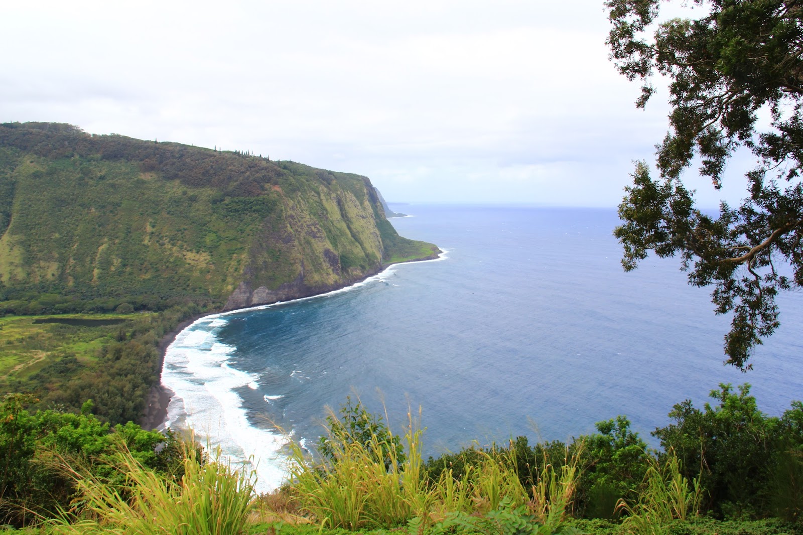
Waipio Valley should be named WipeOut Valley!


Its lure is in its appeal...lush verdant green, ethereal, dream-like escape. Definitely off-the-beaten-path and secluded, do not fool yourselves though, even if you're the footloose and fancy free types, hiking down to the valley floor and back is not for the fainthearted. You have been warned! 


But what tropical paradise aptly named 'Valley of Kings' wouldn't one want to hike down to? Waipi’o Valley is arguably the most magical place on the Big Island. Always listed among the most beautiful spots in the State of Hawai’i, this valley is as hauntingly lovely as it is distressingly difficult to see in its entirety.

There is a 4WD (only) road down into the valley from the lookout but you really (and I mean REALLY) do not want to drive it, even in a four-wheel drive vehicle. The road is incredibly steep (25 - 40% grade!!), poorly paved, always narrow and winding, unbelievably hazardous and tricky and populated by local drivers who really do not want you on their road. And as you get to the bottom, the muddy, puddle-strewn unpaved road is a quagmire during rain.
Perhaps the most satisfying way to see Waipi’o Valley, however, is the way the ancient Hawai’ians did, by walking forthrightly down into it and then crawling, wheezily, back up inch by inch. However, if you attempt this hike, don’t be deceived by the numbers. The hike may entail less than a thousand foot elevation loss (and subsequent gain to climb out) and fewer than 2-3 miles actual walking, but it feels much longer; it is hard, hot, muddy, steep and, oh yes, did I mention hard and steep? But the views and the experience to be had by making this difficult hike are well worth the price of sweat and time. So you might be WIPED OUT at Waipi’o, however, you’ve earned your bragging rights to some great story-telling from the trip.

You start from the lookout point or as I like to call it: succumb-to-temptation point! The panorama that unveils in front of you is unsurpassable. Take your mandatory ‘before’ picture here! Those who are on a time crunch or decide to skip going down into the valley have only visually treated their eyes to a tantalizing dessert laid out artistically on a platter before them. Alas, their palettes are denied the sinful and oh-so fruitful temptation to taste. 
The hike down into the valley takes about ½ an hour with beautiful panoramic vistas to admire at every turn and bend. Plan twice that for exploration of the valley floor and beach and at least an hour to walk back up. Be ever vigilant when walking on the road; local drivers will not deign to give you right of way and tourist drivers are notoriously at the very edge of losing control. Uphill always has the right of way. 

To reach the beach, simply stroll down the road; near where the road hits the valley floor, there is an intersection where you will need to take the road to your right (toward the ocean) which goes along public access to the beach and a spectacular 300 foot waterfall. Once the Waipi'o Valley Road reaches the valley floor, it becomes a mystical, marvelous tree-tunnel through the jungle. The weather could be cloudy, wet, drizzly, cool, sunny, hot and everything in between. That’s the climate forecast for the Big Island in a nutshell. Also, this section tends to be the muddiest with large pools of water covering most of the path which made it fun trekking through thick forests in order to avoid the muddy waters. 

Waipi’o valley is stunning, dramatic and breathtaking. The first view of the beach is a divine sight to behold. Having never stepped foot on a black sand beach before, its uniqueness is a gift in itself. Soft to the touch, fine sand and rock line its shores. We were very lucky to also see the Kaluahine Falls on our right hand (east) side once you get to the beach. These falls only exist when it is raining a LOT. The beach is split in two by the river coming out of the valley, and depending on the amount of water it could be difficult to cross. 

Yet it is marvelous. Take a moment to absorb what surrounds you. 

It is pristine nature in all its glory. It is the mighty ocean in all its supremacy. It is a blessed land that we mustn’t take for granted. 

Waipi’o Valley is a mystical place that defies the powers of written description and although you cannot help going on picture-taking binge, photographs hardly do it adequate justice. This beach is known for its rip currents and high surf, making it a dangerous place to go swimming especially during the winter months.


And then comes the return trip! All the best. It takes grit, muscle and sheer determination to power your way back up the steep gradient. Unless you are in top physical condition, you will need to take a few breaks on your way out to catch your breath.Trust me, you will be wiped out by the time all is said and done. Our comic relief was watching visitors tra-la-la-ing their way down. We now know what lies in store for them. And don't forget to get your 'after' picture to brag...that is if you still have the inclination (pun very much intended)!! Regardless, it’s an unforgettable experience to be had and a place worth the visit. You will cherish it for many years later. 

TIP: Take plenty of water with you as no fresh drinking water is available. If the parking lot near the Information Booth is full, park along the road leading there. Lock your car. 

Thursday, March 09, 2017

Chain of Craters drive into No man's land

It is one of the absolute must-dos inside the National Park. The road is very accessible, drive able with several pull-outs to step out and walk short distances to view points and magnificent vistas. It may very well be one of the most unique driving experiences you have on the Big Island, although after staying there for 5 more days, it gets increasingly difficult to pick this one as your only favorite! 

Stretching approximately 18 miles and going from 4,000 ft. elevation to sea level, the Chain of Craters scenic drive along the East Rift Zone of the volcano in Hawaii Volcanoes National Park is pock marked with craters of varying shapes and sizes, lava flows, petroglyphs, and much more. 
If your ultimate goal is night time lava watching, you may want to start out on Chain of Craters several hours before sunset in order to reach the end of the road with enough time to get out to the lava before dark. Add extra time (2-3 hours) if you plan on doing any of the hikes along the road or if you plan on picture taking! 

One of the stops along the road is the Lua Manu Crater - the first of several marked craters along this road. Lua Manu is a pit crater which is formed when magma below the earth's surface drains, causing the earth to collapse. The 1974 flow sent lava pouring into Lua Manu's basin which is 109 yards in diameter. 

Further down the road, you will see a small pullout on the left which leads to another pit crater, Puhimau Crater. Its fascinating and a surreal feeling to be viewing craters so up front, and those that erupted not more than 30-40 years ago! 

Thurston Lava Tube - don't miss it. What is a Lava Tube? As magma moves underground it flows through tubes. The main magma chamber will have side tubes which are fairly large... these will splinter off into smaller and smaller tubes just like the veins in your body.

The larger tubes can be quite big. They can have ceilings that are 30 to 50 feet tall. Typically the magma that normally flows through a tube fills it about 2/3 of the way up. The heat and pressure will sometimes cause portions of the roof of the tube to collapse, exposing the interior of the tube to the outside through the collapsed roof, called a skylight.
Thurston Lava Tube is an excellent example of a large feeder tube. 

Hilina Pali Road The 8.2 mile trip down narrow Hilina Pali Road has its own rustic and raw appeal in terms of gorgeous scenery. Beauty as always lies in the eye of the beholder here. The barren desolate hardened ground speak of tumultuous times when lava erupted or earthquakes rattled at its very core breaking new ground, engulfing all that came in its wake. It is a story of death, devastation but also one of resilience, regeneration and power. 


Although it is so desirable and alluring to trek for miles into this barren unobstructed underworld...the strong straight line winds whip you around testing your balance. Getting a picture here calls for some serious skills...where the camera, the subject, the surroundings and God forbid YOU all have to make it into one frame! Good luck. 

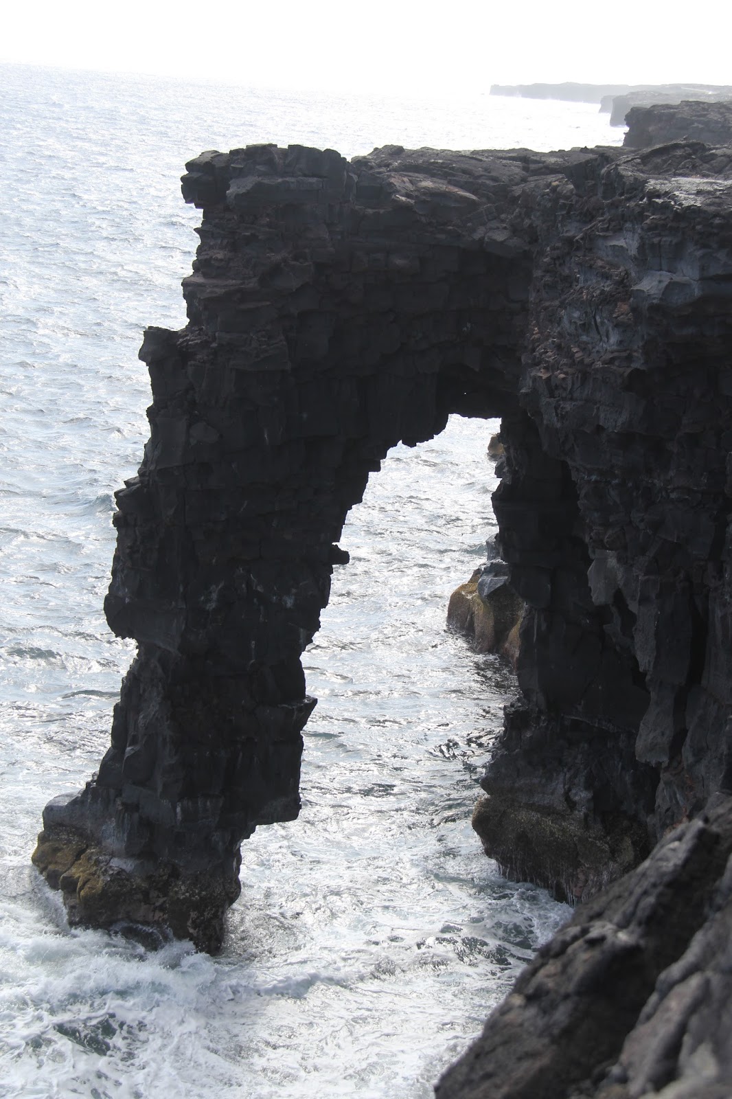
However, the awe-inspiring views at the end of this road are worth the effort if you have the time. The road continues to twist and turn over the bumpy and rutted pavement until you finally reach the Holei Sea Arch. Sea arches are formed when lava is continuously pounded by the surf until it is undercut in the shape of an arch.In a park where the main attraction is an ever-changing force of nature, there is no telling how the landscape could change. Since 1983 Kilauea has been eating portions of the Chain of Craters Road and covering the villages on it with its lava flows. 

Never-the-less its lure is in its drama. In experiencing the true youth of the Big Island and the reality that it is still being born. 


Currently the park allows visitors to walk 5 miles (one-way) down Chain of Craters Road to where the lava begins. This is rough terrain walking. If you plan on hiking beyond where the lava meets the road please take a few precautions. Bring plenty of water, approximately three quarts for the entire hike. Carry rain gear, sun block, and flashlights. The temperature drops with the sun, so carry a lightweight jacket or sweatshirt just in case. There is another option of viewing the active lava flowing into the ocean. See Kalapana Lava Hike 


Rocky Ride into the orange glow

No one is entitled to see the lava on the Big Island, its ebb and flow is very dynamic, ever changing. We were lucky to be visiting at a time when in the recent past 13 year history, the lava out pour into the ocean has been a phenomenal sight to behold. 


There are very few places on earth where you can see lava in person. And even fewer where you can walk right up to it. Kalapana on the Big Island of Hawaii is the safest and easiest access to see actual lava flow. The added bonus here was that there was an option to rent bikes to get to the fiery spout approximately 4-5 miles away. 


Although it is a long and circuitous route to the south eastern tip of the island by car it is definitely an experience to be had and one not to the missed! 
Renting bikes was a very easy process, the vendors are right around the car park area. Make sure to test ride the bike and adjust seats etc before riding into a magnificent sunset. 


And what a bike ride it was! While going in, the wind is at your back...making it an easy exhilarating one. As you bike (or hike which is also an option) across the fields of lava its difficult to imagine that Kalapana used to be home to a fishing village. In 1986, lava started flowing out of the Kīlauea volcano toward the town and ended up destroying it. The lava continues to flow to this day and the town is now completely buried. So although it was a thrill ride across unimaginable landscape and a chance to marvel the unstoppable force of nature, a point to remember is that it is a historical site and reverence should be had for the residents that lost their homes. 


Someone described the surreal landscape as the crust of a freshly baked brownie...burnt to some extent and magnified thousand fold. 

The molten lava hardens so fast that the rock still looks like its in motion. With bumps and cracks, swivels and spirals, deep crevices , its tricky to walk on them..and headlights or flashlights are necessary if you're attempting to hike it after dark. Bear in mind, this isn't an easy hike and definitely leave your fuzzy slippers and flip flops behind. Here you experience the untamed side of the ever-changing Big Island with new land forming right beneath your feet! 

At end of the 4.5 miles gravel bike path, you abandon your bike to walk by foot another half mile over the crusty uneven terrain to get to the edge of the ocean cliff. Lo and behold what words cannot describe, it is a sensation, a reawakening of sorts, a wondrous phenomenon to watch. From here you can witness a torrent of lava gushing into the Pacific almost in a perfect waterfall like pattern. It is one of the most amazing events we have witnessed. 


What was spectacular was the rate at which the hot magma, seen as a strong flow of bright orange molten rock, was hitting the sea. At Kīlauea's ocean entry, the interaction of molten lava flowing into cool seawater caused pulsating littoral explosions that threw spatter (fragments of molten lava) high into the air along with clouds of bellowing dense steam. It was indeed a 'Fire-hose' of molten lava plummeting into the deep sea.


There are hot and deep earth cracks running parallel to the sea cliff around the entry point and it’s a very unstable and hazardous area! The park staff has cordoned off sections and determined the safe zone from where the viewing is spectacular. Pay heed to this! The views from here are breathtaking and you find yourself just standing in awe and appreciation of the sheer force and power of mother nature. A definite must see and must do experience on the Big Island. One that will take your breath away and leave you with a lasting impression deep within. 

Tip: Carry water, headlights or flashlights. Wear sturdy shoes and heed the caution signs. The last thing you want to leave behind is a part of your melted foot! 


Wednesday, March 08, 2017

The Crater within the Caldera

Without a doubt, the star attraction on the Big Island is the youngest yet very much alive Kilauea volcano which has been constantly erupting from vents either on its summit (caldera) or on the rift zones since 1983! Yes...for more than 30 years, its considered to be one of the most active volcanoes in the world! Needless to say it was the first thing we wanted to see and experience first-hand.

Bless the patient park rangers at the Hawaii Volcanoes National Park who see thousands of visitors daily and field the number one 'burning' question on everyone's mind....'where can I see the lava flow from'! Because the flow of lava is so dynamic, the access to view it also follows suit. Best advise is to start at the visitor center and get the latest maps, view points and guide before you set out. It helps you plan your day(s) as well. 


The Jagger Museum overlook off the crater rim drive has an uninterrupted view of Halemaʻumaʻu Crater which is a pit crater located within the much larger summit caldera of Kīlauea (see note below on the difference between a crater and a caldera) This crater is currently active containing a lava lake from where the near-permanent gas plume rises. 

How does one describe watching a crater billow with smoke and glow from a lava lake that’s hundreds of feet below the surface? Somehow the words amazing and incredible just don’t do enough to adequately describe this sight.

Ideal times to see Halemaʻumaʻu's eruptive activity is around dusk and dawn where you have an opportunity to see both the red glow from the lava lake as well as the plume.


Note: Volcanic craters and calderas differ mainly in the way they are formed. Craters tend to be more nearly circular than calderas, and they are often, though not always, smaller than calderas. Craters are the vents through which gas and magma are ejected, while calderas form as a result of local collapse of the surrounding rock.

What to know when you go:
Since Halemaʻumaʻu is located within Hawaii Volcanoes National Park, you must pay a $10 fee for park entry. This fee allows you entry in to the park for 7 days. There is plenty to see and do inside the park besides Halemaʻumaʻu. If you have the time, you could easily spend 2-3 days here. 

The Gift


With incredible adventure at every bend and turn, our first-time Hawaiian vacation to Big Island and Oahu was by far our most physically challenging vacation yet! 
The Islands offer an astonishing array of topography and an undoubtedly wild ride passing through rain, clouds, sun, shade, winds and did I mention winds! 

Yet nowhere else have we been so confronted by the power and stark beauty of nature; wonder struck by the brilliance of a stellar star-studded sky; overwhelmed by the combined forces of elements; loudly reminded of how alive and powerful this earth is. 

The Big Island lives and breathes like nowhere we’ve been before — perhaps because it’s still being formed beneath our very flip-flops, with lava constantly creating new landmass.

Here, the ‘Aloha’ spirit which is a well-known reference to the attitude of friendly acceptance also refers to a symbiotic relationship and an acknowledgement of that relationship with everything in the universe around you, and recognizing exactly what your space within that is.

In the Hawaiian language, aloha stands for much more than just “hello” or “goodbye” or “love.” Its deeper meaning is “the joyful (oha) sharing (alo) of life’s energy (ha) in the present (alo).” And THAT was Hawaii’s gift to us, the monumental power of ‘now’, which pretty much sums up our experience!

Friday, February 26, 2016

Ziplining high above the canopy

Zip Lining: The minute one foot steps off the ledge, you'll understand the remarkable difference between standing on the edge of something beautiful and actually taking off into the clouds soaring like a bird....to live and breath it! 


By far Costa Rica's most popular adventure sport to indulge in...this one calls for some stomach although it handsomely rewards you after! There are many outfitters in almost all the popular travel destinations in Costa Rica. If you really want to feel what soaring like a bird feels, then my recommendation is to go for it either in Arenal/La Fortuna or in and around the Monteverde/Santa Elena cloud forest. We chose the latter and boy, were we in for a ride of a lifetime!  The two largest companies here are Selvatura and Sky Adventures...both equally good and very comparable. You couldn't go wrong with either. My reason for picking Sky was because it included a tandem ride and what better way to experience unbridled joy and the adrenaline rush with a loved one. 


Sky also has a gondola/tram ride that takes you all the way up more than 10,000 feet building up serious anticipation along the way. It also gives you the time needed to strengthen your guts or chicken out (just kidding)!! 


The pre-flight training instructions lasted all of 4 minutes...not what I was expecting! And just before stepping off the ledge....the instructors tease you about having signed the life or death waiver! As funny as it sounds the first ride was scary as hell. But the second got better and the third even more. After that, I found myself wanting to do this all over again and couldn't get enough of it. 
Its one of the most exhilarating experiences we've had - Zip lining high above the tree canopy meandering in and out through the clouds, feeling almost bird like. I'm sure fellow sky divers and zip liners can relate. Zip and zoom and try a canopy tour once in your lifetime. You won't regret it. 


Going solo has its ups! Hiking at La Paz waterfalls

 The La Paz waterfalls, outside of the city of San Jose, CR are spectacular, hands down! But what made it even more extraordinary was that it was my solo adventure there and I picked possibly the wettest rainiest day to hike it. But guess what, I wouldn’t change anything! If you ask me, I would say, go, particularly in the rain…and have the best experience of your life! If you don’t come back smiling, then contact me, I know some seriously good shrinks!!


The thick mist, descending clouds amidst a rain forest buzzing with activity was actually out of a movie scene. From croaking frogs and fluttering butterflies to fleeting hummingbirds, there are plenty of creatures to be found in this wildlife-lover's paradise. And for a nature-lover like me, the five flowing waterfalls were reason enough to want to see it. The green poncho made do for a sexy hiking outfit, one that perfectly fit with nature and made me feel a part of it. And once on the trail, I soon realized that I was the only one there, probably crossed 3 other people in total over a time period of 3 hours! Even better!

The riverside concrete trails lead steeply downhill to the waterfalls. Standing on the viewing platform at the Templo Fall, you’re pummeled by spray blasted from the base of the fall. Poncho or not, you are getting wet! Guaranteed! At one point you can almost go behind the waterfalls…I was beaming with delight like a kid in a candy store! Continuing downriver, a metal staircase that clings to the side of the cliff descends to the Magía Blanca (the largest cascade), Encantada, and the La Paz falls. From here you can actually see three waterfalls simultaneously. 

It was a thrill and the rain actually accentuated the entire experience! It’s a daunting climb back, steep and hundreds of steps but oh so worth it. Your sore legs the next day remind you of what a great time you had! Definitely a must-do.


Thursday, February 25, 2016

Pura Vida Costa Rica


Costa Rica is an amazing country and the best gift I received from it was conquering my fears!! Yes, plural! A very dear friend, philosopher and mentor once drew on my white board that in order to grow, you have to step out of your comfort zone and sometimes that would mean stepping into the terror zone! (Yes, you know who you are…and I’m ever grateful to that pivotal moment in my life). If something terrifies you, you should totally do it BECAUSE it terrifies you. And then you'll do it and you'll realize what you're capable of.

So on this trip, I literally stepped in with both feet forward and climbed atop an active volcano, walked on swaying monkey rope bridges, climbed tall steel towers, went for a midnight forest walk to experience the reptilian genus and zip lined high above the tree canopy – all for the first time and almost all that I would gladly do over and over again (minus, you guessed it …the reptilian adventure)! And through it all, I realized that if I would not have done something, right now, I would never get to live my dreams in waiting! I also realized that it is during the times I am far outside my element that I experience myself the most. I discover a smile I didn't know I had, I uncover a feeling that I didn't know existed in me... I see myself. I also let out that bit of crazy that lies dormant within most of us….and was amazed at how the most ordinary day could be catapulted into the extraordinary in the blink of an eye! 
This trip gave me a gift, one that is infinite and infinitely rewarding – conquering my fears and I am proud and ever thankful for it! Maybe it’s time to contemplate sky-diving!

Friday, July 17, 2015

Kinderdijk UNESCO world heritage site, a wondrous place


No visit to Holland is complete without windmills...but these are no ordinary windmills. They make quite the story.
A significant part of Holland is below sea level but this isn't noticeable because of an incredibly innovative and intricate system that keeps the ever-rising seawater from flooding the land.
The gorgeous windmills of Kinderdijk which is a UNESCO world heritage site is a testament to water management at its best. The mills and pumping stations drain the excess water into the river that subsequently, flows into the sea.
But enough of the science part....the art is in getting there...quite an adventure on its own....with 2 water taxis, buses and 20 minute walk...not to mention, I picked a day when it was pouring...cold and windy. Nevertheless, the site with 19 windmills was lovely and made for a picturesque country side self guided trip.
Holland windmills- check


Losers...weepers, bicyclers... keepers.

If there ever was a mecca for bikes, it would be Amsterdam and there are good reasons for it. 
Take a relatively small city, add a dash of flat terrain sprinkled with years of investment in cycling infrastructure and you get bicycles for every age, shape, size and profession, plus a national culture that supports their daily use. This clogged stream of cyclists is just one of many in a city as renowned for bikes as Los Angeles is for automobiles or Venice for gondolas.

Cyclists young and old pedal through narrow lanes and along canals. Mothers and fathers balance toddlers in spacious wooden boxes affixed to their bikes, ferrying them to school or day care. Carpenters carry tools and supplies in similar contraptions and electricians their cables. Few wear helmets. Groceries are bought, milk is carried, fresh farm produce along with a good bottle of wine and some cheese packed for a picnic, all on 2 wheels.


I was curious on my travels to Amsterdam, to learn more about this bike-friendly city. I spotted special roads set apart for cyclists, protected from the dangerous automobile by concrete barriers where might I add, even the average pedestrian is at risk for being run-over! But more than that, I found a city where biking is part of everyday life. A city where executives, working stiffs and hand-holding lovers all pedal side by side. The old and the young are equally bike friendly and equally bike fanatic racing along Damrak from Centraal Station to Dam square. Click here for some fun facts about bicycles in Amsterdam.


Though at times, this appeared over obsessive to me, bikes are just a part and parcel of who the Dutch are.They don't over think it. Conversing with a local, when I mentioned that in a city of 800,000 there were 880,000 bicycles, Tuen shrugged his shoulders nonchalantly to say "Most people own more than one bike....they never take their 'good' road bike into town. That is reserved for long weekend breaks out in the country side!" That explains why we mostly saw tattered old 70s and 80s style of bikes chained to lamp posts, pillars and bridges all over central Amsterdam. You'd be lucky to find an available free post or pillar for parking in the heart of the city.

The last thing you want to try is to drive through the center of Amsterdam in a car: you'll quickly realize the city is owned by cyclists. They hurry in swarms through the streets, unbothered by traffic rules, taking precedence whenever they want, rendering motorists powerless by their sheer numbers.
In the past two decades, travel by bike has grown by 40 percent so that now about 32 percent of all trips within the city are by bike, compared with 22 percent by car.
But many Amsterdamers say it is not so much the traffic jams like those at the morning ferry that annoy them most, but the problem of where to park their bikes once they get to where they’re going, in a city with almost more water than paved surfaces.

“Just look at this place!” said Xem Smit, 22, who for the past year has struggled to maintain order at a municipal bike parking lot in the heart of town, waving a hand at bikes chained to lampposts, benches, trees and almost any other permanent object across a tree-lined square between the stock market and the big De Bijenkorf department store. I can't imagine the frustration of not being able to find your bike at the end of a long tiring work day or for that matter finding a parking spot to begin your mornings with, however, so far the most bicycle friendly city has maintained its appeal and kept its secret to its health. 

The flip side to it  of-course is rampant bike theft. Amsterdam Police and the Cyclists’ Union estimate that each year between 50.000 and 80.000 bikes are stolen! Most of them from right outside your house!Yikes! Click here for a humorous take on how to ensure your bike doesn't get stolen. My favorite from this link is to Park your bike near a street light!


Of gabled fame

Amsterdam has been called a city of 'well-mannered' architechture because its charm lies in intimate details rather than in grand effects.
The gabled houses on the Canal Ring are Amsterdam's most picture-perfect historic feature. The infinite array of gables on the city houses dominates the city's postcard-perfect image and is a carefully preserved asset.


From the 15th century onwards, planning laws, plot sizes and the instability of the topsoil dictated that facades were largely uniform in size and built of light weight brick and sandstone, with large windows to reduce the weight. The lack of firm land meant that Amsterdam houses were built on narrow, deep plots, and one of the only ways to make a property distinctive was at the top, with a decorative gable.
Canal house owners stamped their own individuality on the buildings, mainly through the use of decorative gables and cornices, ornate door-cases and varying window shapes.
One thing all canal houses have in common is the hook in the gable, to which a pulley wheel and rope can be attached. This handy manual elevator system was developed from medieval shipping techniques; it's pretty impossible to move bulky goods up and down the precariously steep staircases found inside most Amsterdam houses (trust me when I say that one person could barely fit through those narrow tight stair alleys). Boxes, pianos, couches, or whatever are winched up using the rope and pulley, and hauled in through exceptionally wide removable windows. On my walk through different neighborhoods, I kept my eyes peeled to catch a few Dutch movers in action.

The old center was formed by rings of canals with unique mostly 17th century residences of wealthy merchants, financiers, craftsmen, doctors, lawyers, politicians and artists. Merchant’s houses had their storage in attics and cellars. Sometimes the lift was installed in the middle of the house plan, to transport the goods between floors. The office of the merchant was usually on the ground floor. Like in Venice the canals were the main way of transporting the goods.


Interesting tit-bit - most of the canal houses lean a tad forward to prevent loads crashing into facades!

I could happily 'get lost' here...

Over the centuries libraries have been constructed more than mere book repositories, but as symbols of knowledge, power, and wealth. Today these are wide expansive public spaces that celebrate the connections humble citizens have to civilization and literary culture. I was fortunate to have visited one such stunning pieces of architecture where I would happily 'get lost'! We should be so thankful for a world where such spaces exist.


Sunday, July 12, 2015

Dramatic Ronda

It was the daily picture on Bing that gave us the incredible sight that is Ronda. One look at the photo and we both instantly knew the look! We were definitely including this jewel into our Andalucian itinerary. Perched on an inland plateau riven by the 100m fissure of El Tajo gorge, Ronda is Málaga province’s most spectacular town and I mean it. It has a superbly dramatic location, and owes its name (‘surrounded’ by mountains), to the encircling Serranía de Ronda. The more we read/saw, the more certain we became that this was a must-see destination.

Hardly anybody has ever regretted the 100 kilometers journey from Malaga, passing narrow mountain streets, when suddenly Ronda appears like an apparition. The famous and really breath-taking bridge alone is worth the travel, but Ronda has more to offer: the only bullring in all Spain which is entirely made of stone, and several interesting buildings in particular from the Moorish period.
The city is divided into an older part, which is the Moorish and aristocratic quarter and the newer section to the south bank of the gorge, built principally after the Reconquest. Because of the cliffs, Ronda was one of the last Moorish cities to fall during the Reconquest of Spain by the Catholic monarchs. 
While we were there we tried re-creating that magical inspiration of a panorama that started this in the first place....here it is, and hoping that it inspires you to visit/travel this not-to-be-missed Andalucian jewel. 
 

Jewels of Andalucia

The Spain that one would often read about, or see coffee table books richly illustrate is in fact Andalucia. It is the cradle of Flamenco, the stomping grounds of the amorous Don Juan and one of the last strong holds of the Moors, who held Al-andalus for over 7 centuries!
Its lush landscape, sweeping hills and topography, sleepy white washed villages, ornate moorish castles lured us towards it and spending a week there was just enough to skim the surface!

Ours was a 7 day itinerary flying in and out of the coastal city of Malaga (serviced by an international airport) and traveling clockwise to Ronda followed by Seville, Cordoba, Granada and returning back to Malaga. We traveled by road (and other interesting means of transportation along the way), didn't feel the need to rent a car and were still able to cover little gems of surprises off-the-beaten-path...leaving us with memories to last a lifetime and a spanish vocabulary of 100 odd words to boast!

Thursday, October 23, 2014

Türkiye çok güzel - Turkey is very beautiful!

After traveling in Turkey for 14 days, we came away with much more than a 100-150 word Turkish vocabulary! Enough to appreciate and express (in the local tongue) the raw, rich sometimes divine beauty of this ancient and gorgeous country. Just the very mention undeniably brought a beaming smile on the mild mannered and simple local folks who are at the very core of Turkish heritage and culture and play a major role in defining the overall travel experience there.

When we mentioned Turkey as our destination for our travels, we almost always got 2 reactions...
(1) Turkey, whats in Turkey? Why?
(2) You'll love it!! Its fabulous, wondrous , a dream destination etc etc
...and the ratio between the two reactions was 20:1


We had shortlisted 3 options for our travel and due to the Arab spring uprising (at the time) had to drop a couple choices and Turkey surfaced to the top! After returning, I would say, there probably wasn't a choice needed at all. Hands down, this has been one of the most rewarding and memorable trips of a lifetime. Its also one where we traveled more off the beaten path, let the spontaneously happily happen, and marveled at how rich and extra-ordinary our experiences were because of it.

The country is modern while steeped in history, traditional while embracing the best from the west. The people are her most treasured assets. They are warm, hospitable, cheerful and laid back who take pride in their country and genuinely want you to have a good time. Its their repeated friendly gestures and generosity that enriched our travels and gave the phrase "Türkiye çok güzel" true meaning.

Friday, October 10, 2014

My love affair with Octobers...

I catch myself taking in a deep long breath (all the way from the tip of my nose to the end of my spine)...over and over again. Its finally October! The cool and crisp sun drenched air fill my insides with a mellow warmth wrapped in a cool blanket of freshness that beckons me to step outside, bask in the glorious autumnal splendor and feast on vibrant hues that define the season.
Octobers are ephemeral, if missed, its a loss you have to wait a whole year to compensate. Its when the skies are their bluest, the sunlight brilliant amber, the leaves a myriad of colors apt to describe a painter’s pallet. Its when the simplest of joys - rustling of leaves under your feet, birdsong heralding the changes to come, nestling of the wind, scurrying of squirrels as they fend for winter, translucent sumac that shine crimson gold and burgundy....matter. Its what make this time of year so special and dear to my heart.
So get out there, take in every opportunity to experience the perfectly cool air, late afternoon molten sun, the Monet-inspired picture perfect landscapes, that herald a time of renewal, and underscore the fleeting nature of life.
"I’m so glad I live in a world where there are Octobers." – L.M. Montgomery

Sunday, April 20, 2014

South Padre: Drive till the road goes no further...revel in the dunes!

Even though the island is only 30 some miles in length, its unfortunate that most people don't venture beyond the kitschy surf board shops, restaurants and high rise hotels. But the few who venture beyond the ordinary, come out richer on the other end (literally). This is where extra-ordinary happens!!


Head north on the island (don't worry, there is only one main road) you'll soon be able to drive no more. Here is where fine white sand covers the road and creates this man-made barrier that separates the north and south padre islands.


Its a surreal sight to behold, with soft undulating dunes on both sides of the road. Getting out and climbing the dunes comes naturally, it's pristine because you've effectively left those spring break partying crowds far far behind. Here is where you have the sun, sand, beach all to yourself.